• Follow Chiang Mai Hiking เดินเที่ยวป่าเชียงใหม่ on WordPress.com
  • ABOUT THIS SITE / เกี่ยวกับเว็บไซต์

  • On this website some experienced Chiang Mai hikers post open invitations to join their hikes in the area.
  • We use the date format YY/MM/DD where YY is the year, MM is the month and DD is the day of the month.
  • Hike descriptions may be posted at short notice. So it may be worth checking the website frequently.
  • Hikes may be cancelled or varied at short notice due to weather conditions or other factors. So it is advisable to check the website beforehand on the day of the hike.
  • ผู้มีประสบการณ์ในการเดินป่าที่อาศัยอยู่ในจ.เชียงใหม่ เป็นผู้โพสต์เชิญชวนให้คุณมาร่วมเดินป่าด้วยกัน รูปแบบ YY/MM/DD ที่ใช้ในเว็บไซต์นี้ YY คือ ค.ศ. MM คือ เดือน และ DD คือ วัน บางทริปอาจมีการโพสต์ขึ้นใกล้ๆกับวันเดินทาง จึงควรหมั่นเช็คข้อมูลในเว็บไซต์บ่อยๆ นอกจากนี้การยกเลิกหรือการเปลี่ยนแปลงข้อมูลก็อาจเกิดขึ้นได้ เนื่องจากสภาพอากาศและเหตุสุดวิสัย แนะนำให้ผู้ที่สนใจเช็คข้อมูลในเว็บไซต์อีกครั้งก่อนการเริ่มเดินทาง

2024/04/28_Baan Huai Mo to Baan Pang Faen

Length 13km; total ascent 620m; expected time 4 1/2 hours.

If there is a spike in air pollution, or fires are reported in the hike area, it may be necessary to cancel. Any notice will be posted on this site before 06.00.

This is a hike that follows a ridge line parallel to, and NW of, Highway 118. There will be a short 3km car shuttle between the start and end points of the hike, at Baan Huai Mo and Wat Prabhat Pang Faen respectively.

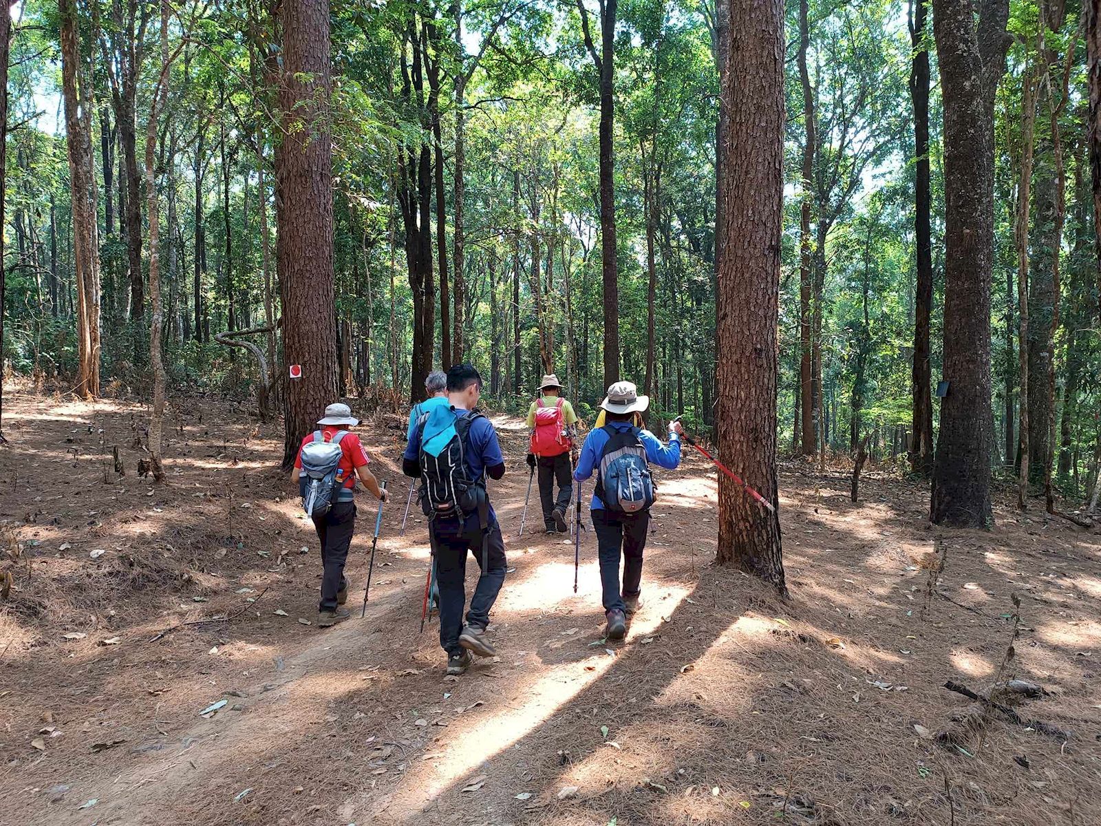
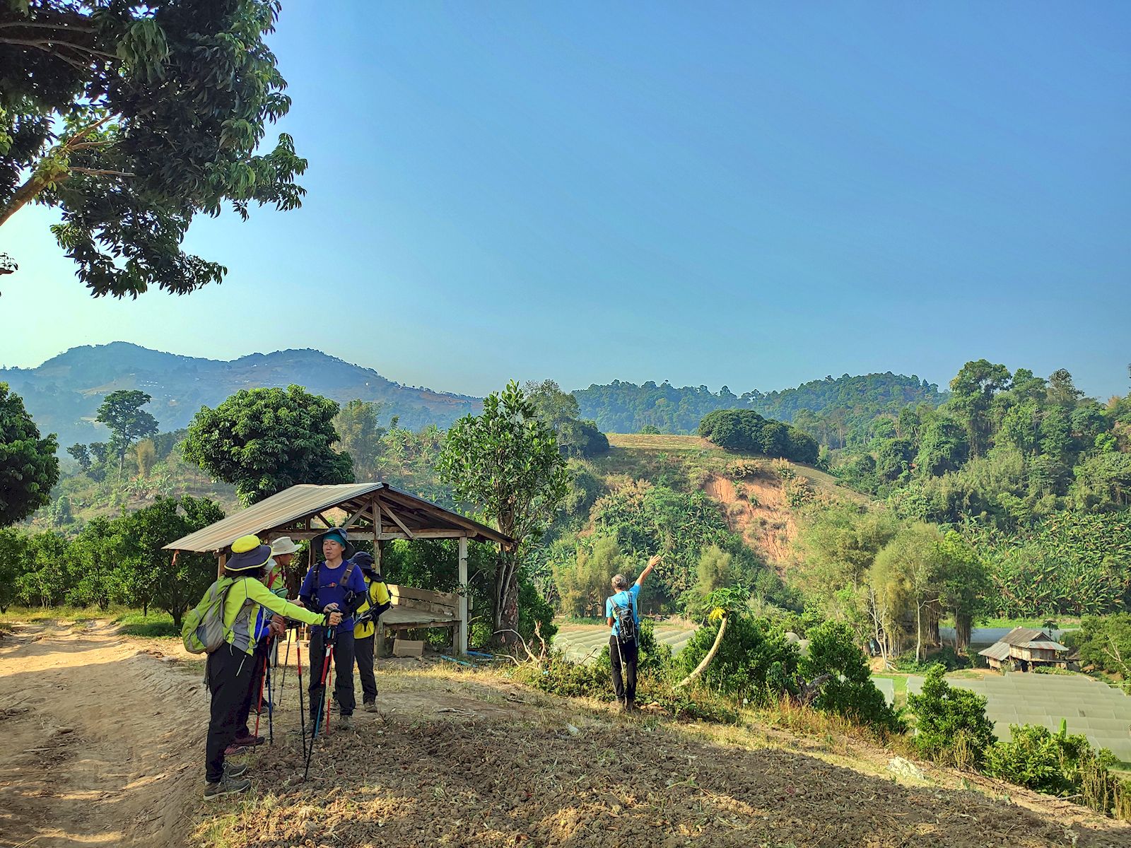
The hike starts from close to Baan Huai Mo (but not in the village itself). Initially we pass through open agricultural area, but soon turn off onto a forest trail that climbs steadily up to the ridge line. Once on the ridge line, the plan is to follow the ridge due north to a rocky outcrop, which offers the best views along the entire ridge and makes for a nice picnic stop.

After taking refreshments, we will return along the same trail to the point at which we accessed the ridge and then turn SW in the direction of Baan Pang Faen. After 3km of ridge walking, we turn off on a steeply-descending trail leading back to the vehicles parked at Wat Prabhat Pang Faen.

There are fairly steep sections both up and down, but nothing that should cause any difficulty. Trails are good throughout. The ridge is at an elevation of just over 1,000m and is usually pleasantly cool and breezy. Most of the hike is through forest cover, but take hats and sun protection for the more open sections.

The northern excursion to the rocky outcrop comprises about 3km and 150m of elevation of the quoted hike parameters. Those lacking energy and with plenty of patience, could wait on the ridge for the return of the group, reducing the hike to 10km and 470m of elevation. This would, however, mean a long wait as well as missing the trip highlight.

Hike Organiser: Richard

If you would like to attend: Please read the general information on this site, as well as this particular post. If you still think this hike is for you, then just turn up at the meeting place on the day and time. Lifts in cars are usually available, but cannot be absolutely guaranteed. For passengers, please offer the driver TB100 towards fuel cost.

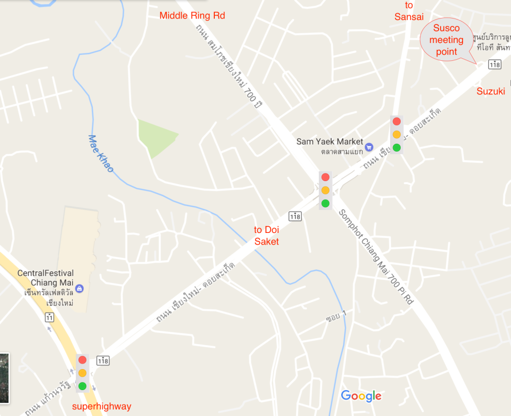
Meeting Point: in front of the ESSO (previously SUSCO) filling station on Highway 118 at 07.20 for a 07.30 departure.

This image has an empty alt attribute; its file name is image-2.png

Initially we will drive in convoy for about 40km along Highway 118 to Wat Prabhat Pang Faen, the end point for the hike https://maps.app.goo.gl/sN7B8Q55b8pzfGJd6. Most of the vehicles will be left here and hikers will transfer into the fewest possible vehicles for the 3km onward journey to the hike start point near the village of Baan Huai Mo, where space for parking is very limited. For anyone wishing to drive direct to the hike, please head to Wat Prabhat Pang Faen.

Please bring: as per usual advice (see tabs above), but bearing in mind this is the HOT season pay particular attention to the following:

  • Plenty of water and/or electrolyte drink.
  • Hat.
  • Sun-screen
  • A snack or light lunch to consume at the viewpoint.

2024/04/21_Report_Mon Jaem forest loop

A total of eleven people turned up at Mon Jaem, eight to do the main hike and three to walk a shorter version. Pollution levels fluctuated but were high enough to prevent any decent views of the surrounding countryside. With a our relatively small numbers we made good time and reached the lowest point of the hike in under two hours, accompanied by a canine volunteer from the village. As the path became steeper the pace slowed somewhat but the group stayed together and we reached the main viewpoint in about two hours and a half hours.

Just before we reached the viewpoint we came upon a somewhat incongruous situation: a large group of Hmong villages (apparently celebrating their New Year) sitting beside a large open fire, with the intention of roasting three recently slaughtered pigs and somewhat oblivious to the potential threat of forest fires. At this stage our canine volunteer deserted us with the hope of better pickings at the barbecue. We finished the 9km hike in about three and a half hours, just behind the smaller group which finished about fifteen minutes before us. Afterwards most hikers adjourned to the Between restaurant for food and refreshments.

Exploring the stream bank near the new causeway at Between

Hike leadership and reporting by SRR. Photos from Kurt, Othmar and Michael.

2024/04/14_Report Khanin Valley (Avocado) Hike

Elephants, avocados and time to ‘smell the roses’…

No fires but with the air still in a less than optimal state, 6 hikers joined the hike from the Thung Roeng Royal Project. We made good progress in the morning when the heat was not yet at its fullest.

Arriving at the ‘Patara Elephant Conservation’ camp before any other tourists, we spend some baht on food for the elephants. Local celebrity elephant ‘Mira’ and her mother came and enjoyed being feed fresh bananas, and we enjoyed feeding them; a win-win!

A visit to the coffee shop was on order as well. Whilst the avocados at the Royal Project are nowhere ready, here we got avocado ice-cream and avocado smoothies to go with local coffee.

But we must go back on our trail along the Khanin valley. Farms and buffalos, then further along forest and of course the many water crossings of the Mae Khanin. Some tried to keep their feet dry, and succeeded, others did not bother and simply walked through the water.

At the lunch spot, the sala is long gone, but a smoldering campfire was there left unattended. We did the right thing and extinguished it with the water just meters away.

Next up was the steep climb up to our highest point. Some new bike trails zig-zagging along made the climb a little easier than along the old dirt road. From there, back to the trail head by the Royal Project.

After the hike we had a nice catch-up with our friends from the shorter hike at the Royal Rosegarden.

The hike was about 11.5km with just under 300m elevation gain/loss. We completed the hike in just under 4 hours, including stops.

Hike leader & Report: Othmar

Pictures: Prae, Kurt, Jeff, Othmar

2024/04/14_Report_Royal Rosegarden Ridge

On this Songkran weekend, there was just a pair of friends who did the short hike – and not the usual pair. Our doyenne is down with a very nasty ‘flu at present. All best get well wishes to her.

Although the planned route was very short, way-finding proved surprisingly problematic, due to distractingly fun conversations along the way, together with a slowdown in the GPS app, possibly due to device overheating on a very hot morning. So the actual hike stretched out from three to about five km, between the outskirts of a pleasant rural community and a dry forested ridge. Soon after we got back to the Royal Rose Garden cafe, and were sipping our sha-nom-yens, the main group hikers phoned to say they had finished, and drove over to meet us there for some post-hike chat.

Hike leadership and reporting by Michael

2024/03/31_Report Ban Mae Khi loop

We are still in the ‘smoky season’ (but not at its worst), and the air at the trail head at higher altitude was measurably better than down in the city.

After the combined group picture with our friends who ventured on a shorter hike in the area, the ‘7Eleven‘ team (that is 7 out of 11 hikers… the other 4 wend on the shorter hike) went on their way heading into the local vegetables farms and fruit orchards, passing and chatting with some locals in the fields and along our trail.

The trail up to the ridge was a little hot, but we all made it in good time. Some new trails contouring left and right along the main trail were discovered. Maybe something to explore for next time. On the way back with the temperature rising we were lucky enough to catch some cool breezes along the trail.

The question on everyone’s mind; did the Easter Bunny leave some treats for us as he did on our last hike here on Easter Sunday 2 years ago?

Yes, well kind of…

Maybe he sent his apprentice as the Easter Eggs had kind of a strange shape, no shell, a stone at the center, but as it is Easter Sunday, they surely must be delicious juicy Easter Eggs!

The hike worked out pretty much as advertised with 11.5km and 430m up/down. With a smaller group we did the hike in 3:35 hours (incl breaks).

Almost a tradition, our nature corner;

The noodle shop was open and we were able to enjoyed our lunch of various hot noodle bowls and of course some cold drinks and relaxed banter.

Hike leader & report: Othmar

Pictures: Bussakorn, Rung, Kurt, Othmar

2024/03/31_Report_Short variant_Ban Mae Khi Loop

There were four takers for our short hike this week, despite (1) the resumption of longer hikes providing a counter-attraction, (2) an early start, (3) hot weather and AQI levels approaching 200, (4) it being Easter Day, when some might have other things to do, (5) people needing to get stuff finished before the upcoming songkran holidays.

But the four of us had a nice time. Highlights included:

  • being shown the best way by a friendly farmer over a tricky stream-corner next to an orange orchard,
  • leaving an Easter gift on the trail for the main group hikers to find later,
  • re-lodging a pretty but fallen orchid by a forest track,
  • collecting seed-cases that looked like designer baskets or art-nouveau lampshades,
  • eating refreshing mulberries.

We got back to Chiang Mai around noon, feeling we had done enough to earn our naps on a hot and smoky day.

Leadership and reporting by Michael. Photos from Michael, Janet, Nan and Nuam.

2024/03/24_Report_Not the Crying Dogs waterfall

We started with a group photo dedicated to CMH friend and legend, David G, who has just started the path to recovery from a serious road accident.

After a midweek rain shower, the improved weather and air quality – although the AQI was still above 100 – brought actually the sort of morning when you want to bounce into life. We had a good turnout of 14 hikers, including some fresh faces.

On setting out toward the Crying Dogs waterfall, we had just walked past a big new sand-mining quarry when a local resident scooted up to us and explained that the area was within the national park no-go zone designed to prevent fire-starting. We duly turned back. There were apologies from the leader, who had forgotten about this aspect when he posted the hike, but everyone took it well, and all-but-one immediately signed up for a Plan B.

Plan B was to do a short loop featuring the stair climb from Wat Ban Pong to the White Pagoda (which is constantly becoming more magnificent). Two different short loops, actually: both taking in the forest path to the standing Buddha behind the pagoda (and the Buddha footprint where monks were holding a ceremony), but one cutting back very quickly to the access road, and the other doing something different, as explained by its ever-resourceful impromptu leader, below.

Othmar writes:

We enjoyed the hike up the stairs to the White Pagoda with our combined group. Re-grouping at the top, from a surprising large group, only 3 decided to tackle a slightly longer version from the top of the White Pagoda back down to the temple.

The extended hike was all on good trails. A couple climbs, a couple of decision points; small trail straight up the hill, or more prominent path a slightly longer way around..? We headed straight up.

Lesson learned, at the second, shorter hill we took the slightly longer, but more gentle way around.

From there we followed farm roads along orchards with beautiful views back to the White Pagoda and into the valley to the south.

The hike, from the parking lot at the bottom of the stairs back to same; 5.8km with 280m altitude gain/loss in 1:50min.

This energetic sub-group reached the Ozarks only about half an hour after the casual-strolling majority, so in time for its members to be included in our concluding group photo.

Leadership and reporting by Michael and Othmar. Photos by Michael, Othmar, Janet and Young-hee.

2024/03/17_Report_QSBG hike

With AQI in the range 150-200, four hikers turned out for this shortish hike at Queen Sirikit Botanical Gardens. There was no concession for elderliness at the ticket booth, which was perhaps fair enough since you are as young as you feel, and we all felt pretty young.

Contrary to the prior hike notice, the leader proposed doing the loop in an anti-clockwise direction, and the other hikers co-operated with good humour, even when it turned out we were spending too long in the maze of paths in the lower-middle of the gardens. By the time we reached the main viewpoint (pictured above), the idea of walking the new forest/hill paths on the east side needed to be abandoned, although two of us did go up to the start of that path in order to check it was real and not just a cartographic fancy.

We re-grouped for coffees and ice-creams in the cafe by the canopy walkway, before completing the downhill stretch of our ramble.

Three of us retired to Between cafe, where we found they have built an interesting new walkway and swinging bridge extension going some way up the stream valley.

Hike leadership and reporting by Michael. Photos by Michael, Janet and Bussakorn.