• Follow Chiang Mai Hiking เดินเที่ยวป่าเชียงใหม่ on WordPress.com
  • ABOUT THIS SITE / เกี่ยวกับเว็บไซต์

  • On this website some experienced Chiang Mai hikers post open invitations to join their hikes in the area.
  • We use the date format YY/MM/DD where YY is the year, MM is the month and DD is the day of the month.
  • Hike descriptions may be posted at short notice. So it may be worth checking the website frequently.
  • Hikes may be cancelled or varied at short notice due to weather conditions or other factors. So it is advisable to check the website beforehand on the day of the hike.
  • ผู้มีประสบการณ์ในการเดินป่าที่อาศัยอยู่ในจ.เชียงใหม่ เป็นผู้โพสต์เชิญชวนให้คุณมาร่วมเดินป่าด้วยกัน รูปแบบ YY/MM/DD ที่ใช้ในเว็บไซต์นี้ YY คือ ค.ศ. MM คือ เดือน และ DD คือ วัน บางทริปอาจมีการโพสต์ขึ้นใกล้ๆกับวันเดินทาง จึงควรหมั่นเช็คข้อมูลในเว็บไซต์บ่อยๆ นอกจากนี้การยกเลิกหรือการเปลี่ยนแปลงข้อมูลก็อาจเกิดขึ้นได้ เนื่องจากสภาพอากาศและเหตุสุดวิสัย แนะนำให้ผู้ที่สนใจเช็คข้อมูลในเว็บไซต์อีกครั้งก่อนการเริ่มเดินทาง

2024/04/28_Baan Huai Mo to Baan Pang Faen

Length 13km; total ascent 620m; expected time 4 1/2 hours.

TODAY’S HIKE IS ON

If there is a spike in air pollution, or fires are reported in the hike area, it may be necessary to cancel. Any notice will be posted on this site before 06.00.

This is a hike that follows a ridge line parallel to, and NW of, Highway 118. There will be a short 3km car shuttle between the start and end points of the hike, at Baan Huai Mo and Wat Prabhat Pang Faen respectively.

The hike starts from close to Baan Huai Mo (but not in the village itself). Initially we pass through open agricultural area, but soon turn off onto a forest trail that climbs steadily up to the ridge line. Once on the ridge line, the plan is to follow the ridge due north to a rocky outcrop, which offers the best views along the entire ridge and makes for a nice picnic stop.

After taking refreshments, we will return along the same trail to the point at which we accessed the ridge and then turn SW in the direction of Baan Pang Faen. After 3km of ridge walking, we turn off on a steeply-descending trail leading back to the vehicles parked at Wat Prabhat Pang Faen.

There are fairly steep sections both up and down, but nothing that should cause any difficulty. Trails are good throughout. The ridge is at an elevation of just over 1,000m and is usually pleasantly cool and breezy. Most of the hike is through forest cover, but take hats and sun protection for the more open sections.

The northern excursion to the rocky outcrop comprises about 3km and 150m of elevation of the quoted hike parameters. Those lacking energy and with plenty of patience, could wait on the ridge for the return of the group, reducing the hike to 10km and 470m of elevation. This would, however, mean a long wait as well as missing the trip highlight.

Hike Organiser: Richard

If you would like to attend: Please read the general information on this site, as well as this particular post. If you still think this hike is for you, then just turn up at the meeting place on the day and time. Lifts in cars are usually available, but cannot be absolutely guaranteed. For passengers, please offer the driver TB100 towards fuel cost.

Meeting Point: in front of the ESSO (previously SUSCO) filling station on Highway 118 at 07.20 for a 07.30 departure.
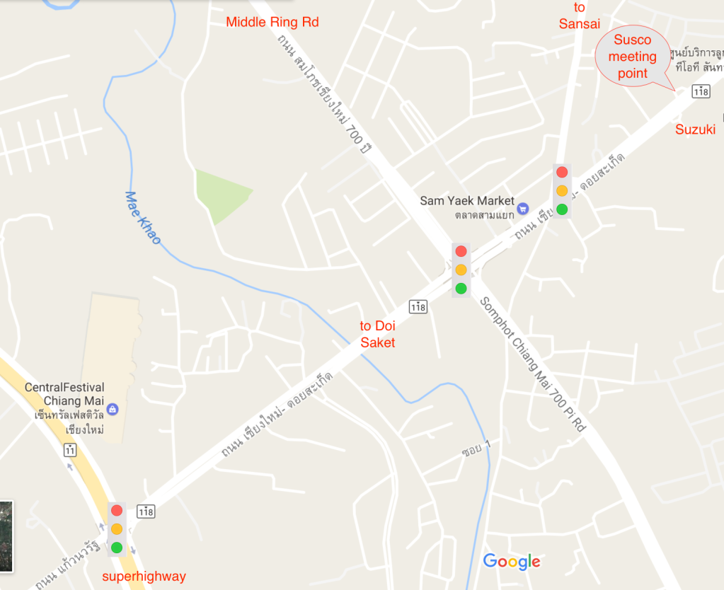
This image has an empty alt attribute; its file name is image-2.png

Initially we will drive in convoy for about 40km along Highway 118 to Wat Prabhat Pang Faen, the end point for the hike https://maps.app.goo.gl/sN7B8Q55b8pzfGJd6. Most of the vehicles will be left here and hikers will transfer into the fewest possible vehicles for the 3km onward journey to the hike start point near the village of Baan Huai Mo, where space for parking is very limited. For anyone wishing to drive direct to the hike, please head to Wat Prabhat Pang Faen.

Please bring: as per usual advice (see tabs above), but bearing in mind this is the HOT season pay particular attention to the following:

  • Plenty of water and/or electrolyte drink.
  • Hat.
  • Sun-screen
  • A snack or light lunch to consume at the viewpoint.

2024/04/21_Report_Mon Jaem forest loop

A total of eleven people turned up at Mon Jaem, eight to do the main hike and three to walk a shorter version. Pollution levels fluctuated but were high enough to prevent any decent views of the surrounding countryside. With a our relatively small numbers we made good time and reached the lowest point of the hike in under two hours, accompanied by a canine volunteer from the village. As the path became steeper the pace slowed somewhat but the group stayed together and we reached the main viewpoint in about two hours and a half hours.

Just before we reached the viewpoint we came upon a somewhat incongruous situation: a large group of Hmong villages (apparently celebrating their New Year) sitting beside a large open fire, with the intention of roasting three recently slaughtered pigs and somewhat oblivious to the potential threat of forest fires. At this stage our canine volunteer deserted us with the hope of better pickings at the barbecue. We finished the 9km hike in about three and a half hours, just behind the smaller group which finished about fifteen minutes before us. Afterwards most hikers adjourned to the Between restaurant for food and refreshments.

Exploring the stream bank near the new causeway at Between

Hike leadership and reporting by SRR. Photos from Kurt, Othmar and Michael.

2024/04/21_Mon Jaem forest loop

This “old favourite” hike is normally a relatively easy one, along the forested ridges of Mon Jaem with (weather permitting) views to the north (Doi Chiang Dao) and south (Doi Pui). A slightly longer variant of this hike is available for stronger hikers who can navigate the paths marked on Gaia or a similar app. And an assistant leader will be on hand to guide any hikers who wish to go slower than the main group and/or cut the hike shorter .

The hike is mostly under forest shade. Formerly it was entirely on dirt tracks, but recently some sections have been made into (little-used) concrete road. There are a couple of modest hills and a old cliff-top viewpoint with the golden statue of the pre-Lanna king, Khun Wilangka. We will also meander through a small vineyard (no wine on sale, unfortunately) and through the small settlement of Mon Jaem towards the end of the hike. (Young-at-heart hikers will probably have the option of enjoying a box-cart ride down the long slope of dirt track just before the end point). The hike should take just three to four hours and afterwards we will retire for lunch at Between restaurant.

Hike leader: SRR

If you want to come: Check that you have read the general conditions and advice on this website, as well at this particular post. If you still think the hike is for you, just turn up at the meeting time and place. Lifts in cars are almost always available although they cannot be absolutely guaranteed. Some drivers may request you wear a mask in the car. Please offer your driver a fuel contribution of THB 100.

Meeting time and place: 

2024/04/14_Report Khanin Valley (Avocado) Hike

Elephants, avocados and time to ‘smell the roses’…

No fires but with the air still in a less than optimal state, 6 hikers joined the hike from the Thung Roeng Royal Project. We made good progress in the morning when the heat was not yet at its fullest.

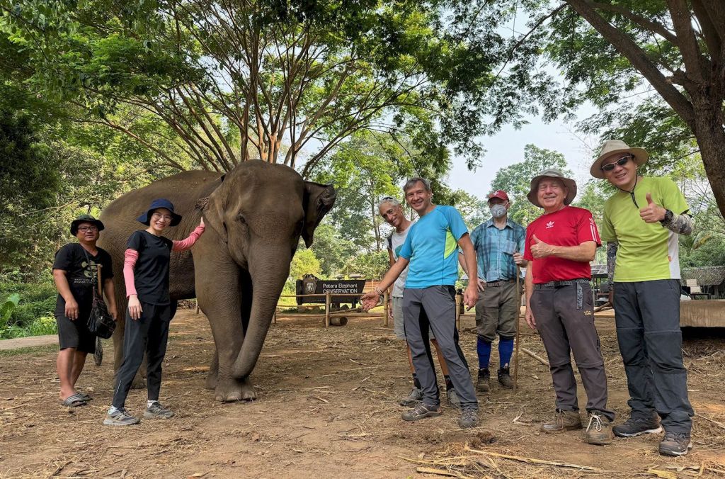
Arriving at the ‘Patara Elephant Conservation’ camp before any other tourists, we spend some baht on food for the elephants. Local celebrity elephant ‘Mira’ and her mother came and enjoyed being feed fresh bananas, and we enjoyed feeding them; a win-win!

A visit to the coffee shop was on order as well. Whilst the avocados at the Royal Project are nowhere ready, here we got avocado ice-cream and avocado smoothies to go with local coffee.

But we must go back on our trail along the Khanin valley. Farms and buffalos, then further along forest and of course the many water crossings of the Mae Khanin. Some tried to keep their feet dry, and succeeded, others did not bother and simply walked through the water.

At the lunch spot, the sala is long gone, but a smoldering campfire was there left unattended. We did the right thing and extinguished it with the water just meters away.

Next up was the steep climb up to our highest point. Some new bike trails zig-zagging along made the climb a little easier than along the old dirt road. From there, back to the trail head by the Royal Project.

After the hike we had a nice catch-up with our friends from the shorter hike at the Royal Rosegarden.

The hike was about 11.5km with just under 300m elevation gain/loss. We completed the hike in just under 4 hours, including stops.

Hike leader & Report: Othmar

Pictures: Prae, Kurt, Jeff, Othmar

2024/04/14_Report_Royal Rosegarden Ridge

On this Songkran weekend, there was just a pair of friends who did the short hike – and not the usual pair. Our doyenne is down with a very nasty ‘flu at present. All best get well wishes to her.

Although the planned route was very short, way-finding proved surprisingly problematic, due to distractingly fun conversations along the way, together with a slowdown in the GPS app, possibly due to device overheating on a very hot morning. So the actual hike stretched out from three to about five km, between the outskirts of a pleasant rural community and a dry forested ridge. Soon after we got back to the Royal Rose Garden cafe, and were sipping our sha-nom-yens, the main group hikers phoned to say they had finished, and drove over to meet us there for some post-hike chat.

Hike leadership and reporting by Michael

2024/04/14_Shorter hike: Royal Rosegarden Ridge

This short alternative to the main hike (posted below) involves going to the Royal Rosegarden (part of the same Thung Rueng royal project as the avocado cultivation), climbing and descending the ridge behind it. This hike is only about 3km, or a bit more if we include walking in the rose garden itself. The ridge ascent/descent is about 150m vertical. We aim to meet the main-group hikers in a nearby restaurant at the end.

Leader: Michael

If you want to join, just turn up at the meeting point on time. No groups please. No need to let us know you are coming. Note that places in cars cannot be guaranteed but are usually available. If you need a lift, please offer your driver 100 baht towards fuel costs.

Meeting times/places

2024/04/14_Khanin Valley (Avocado) Hike

The hike is going ahead. 

This is a relatively easy hike we last did a bit over 2 years ago. We are starting from the Thung Roeng Royal Project, famous for its various types of avocado orchards (sorry, not in season now), but also cultivating many other produces.

We will follow the farm roads to an Elephant camp (always in season 😊) and will stop there for a break. Bring some cash to buy bananas if you like to spend some time and feed the pachyderms. Alternatively, there is also a coffee shop.

From there we follow a dirt-road into the Khanin valley. The first part will lead us along open farmland. Buffalos are normally in residence. A bit further, as we head deeper into the valley there will be a fair number of streams crossings. Depending on the water level, we may get across dry by resorting to some rocks hopping, but be prepared for wet feet.

We then will make a snack stop before starting the only steep part of the hike. The climb is on a dirt road and is not overly hard or prolonged. From there we return to our starting point along some more orchards and vegetable patches of the Royal Project.

After hike refreshments will be in a restaurant back on Samoeng road.

This hike is around 11km long and 310m ascent. The hiking loop should take us around 4 1/2 hours including some time with the elephants and snack break.

Hike leader: Othmar

Meeting point/time: The open area in front of Wat Wutthi Rat (Wat Ban Fon) on the ‘Southern Samong Road’ (#1269) at 07.20am for 07.30am departure. > Google Maps: https://maps.app.goo.gl/cHgJ1dqkpKrAG4eb6

Or ready at 8:00am by the Thung Roeng Royal Project parking area. > Google maps: https://maps.app.goo.gl/9N3jJzZgEQePHgqj8

If you want to join, read our general advice on the above tabs, then if you are sure the hike is for you, just turn up at the meeting point on time. No groups please. No need to let us know you are coming. Note that places in cars cannot be guaranteed but are usually available. If you need a lift, offer your driver 100 baht towards fuel costs and bring a change of clothes/shoes for the return journey.

Please bring: As per usual advice (see tabs above), especially noting:

  • Plenty of water and/or electrolyte drinks.
  • Protection from the heat (start and end sections are exposed).
  • Energy snacks and/or light picnic.
  • Some cash if you like to buy some bananas for the Elephants.
  • Plenty of energy, enthusiasm, good humor, smiles and team spirit.

2024/04/07 URGENT: Today’s hike cancelled!

We have cancelled today’s hike, as there are fires in the area, and AQI readings over 200. Let’s hope for better conditions next week.